San
Francisco Ferry Terminal Readied for September Opening
Alameda-Oakland Riders First to
Shift to Splendid New Facility July 2
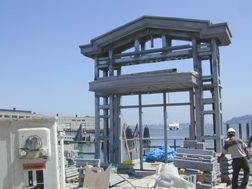 |
| The
Vallejo Ferry approaches one of the new Ferry Terminal Gates
being readied for opening. |
Bay Crossings
spent a glorious May afternoon with Nieret "Nita"
Mizushima, newly appointed Chief Harbor Engineer for the Port of San
Francisco while Nita gave us an update on the construction of the
new San Francisco Ferry Terminal.
This project started back in
February of 2000, so we are into month fifteen of this project. The
base structure is complete but is still awaiting the remaining
aesthetic architectural improvements.
The East Promenade is essentially
a deck structure on the east side of the Ferry Building, which once
complete, will allow the public access along the entire Ferry
Building length between the North Terminal to the Ferry Plaza.
Commuters, the general public, will be able to walk along the entire
waterfront on the water side of the Ferry Building. Before, a boiler
room blocked access, making folks have to double back and go around
the Embarcadero side of the building. No more of that frustration.
We’ve been doing structural
improvements as well. The marginal wharf, which is the structure
between the old seawall and the waters’ edge, is in need of
repair. The sea wall is essentially this big pile of rocks retaining
structure underneath the sidewalk. We’re doing the repairs and on
top of this we will be adding further improvements that will result
in a viewing deck, sort of a raised structure with benches so that
people will be able to enjoy this particular spot and look out on
the water, watch the ferries coming in, docking at the new North
Terminal.
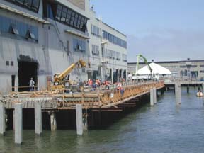 |
| The back side of
the Ferry Building (facing water), on its way to being
opened for pedestrian traffic. |
Once we move over and open up the
North and South Terminals, Pier ½ will no longer be a commuter
ferry terminal. Hornblower has the lease for Pier ½ to create their
cruise terminal. The canopy will be removed and replaced with a new
pedestrian waiting structure for passengers that are going to be
getting on Hornblower’s excursion boats, along with a new
ticketing booth for Hornblower, benches and other improvements
adjacent to the promenade.
The Ferry Building and the new
terminals related to the Ferry Building are intended specifically
for commuters. One neat new features will be a signage program that
will better inform the ferry riders and the general public about how
to connect between the waterside and the landside. As ferry riders
come off of the ferry and exit through our portal structure, they’ll
be able to read a map that shows an axonometric (editors note:
this word, perfect for impressing your friends at Scrabble, is an
adjective meaning drawing only partially to scale and is used
to describe a method of drawing a three-dimensional object so that
the vertical and horizontal axes are drawn to scale but the curves
and diagonals appear distorted) view of the Ferry Building and
the mid-Embarcadero area so that as they’re coming off the
ferries, they can track how they need to go through or around the
Ferry Building to get over to wherever, BART or some restaurant over
at the foot of Market area. And then they’ll also be able to see
this quarter of San Francisco on a separate map, just an overall map
with the major transit information so they can see how to get to
other transit systems, be it BART or Muni or bus system. The sign
structures will have a curved, well-lit surface that will be visible
from a distance. These are new, significant structures with the
flexibility to adjust to future map and schedule needs.
It’ll be the kind of signage
you’d see in the BART station, which makes sense since this is an
inter-modal stop. You’ll see an overall Bay Area water transit
map. Folks will be able to see how to get from San Francisco to say
Vallejo, which ferry terminal you should be coming from and where
the different ferries go. Below that, you’ll also see ferry
schedules for all of the ferry systems
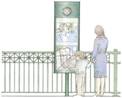 |
| Rendering of the
outdoor signage that will make taking a ferry easier for
commuters and tourists alike. Photo courtesy Roma Design |
leaving from the ferry terminal
to the various destinations. So it’ll be a one-stop shop as far as
getting your general ferry information. We’ll have those sign
masts along the waterfront at both the North and South Terminals and
another one located as you come through the Ferry Building itself,
which won’t be completed until late next year. Additionally, there
will be similar sign masts along the Embarcadero side of the Ferry
Building. Our signage will be consistent with an upcoming signage
system that the City will be using throughout the city to note key
destination points.
There will also be a waiting area
with signage within the Ferry Building itself when it reopens in
about 18 months. There will be a central area for ferry commuters to
wait, and while plans are still in the conceptual phase, you might
see monitors like the kind you see in airports, so that if a
particular ferry is running late, commuters could see that from the
comfort of one of the restaurants planned for the Ferry Building and
just order another drink.
