
Prospect Of Bay Circle
Line: Making Waves Of Imagination
By Michael Nolan
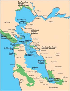 |
| The
Bay, ringed by recreational opportunities accessible by ferry.
Illustration by Yvonne
Chen/ABAG for WTA |
Your relatives back East are
coming to San Francisco. They’re still not sure why you migrated to
California and want some convincing answers. You’ve got to show the Bay
Area at its best. And there’s the clue… the Bay itself… that
magnificent body of water that unifies this scenically spectacular region.
To orient your guests, you’ve
chosen a trip on the Sausalito Ferry with its marvelous views of the
Golden Gate and Bay Bridges, the San Francisco skyline, Alcatraz and Angel
Islands, and gentle approach to the Sausalito waterfront.
But hold on a minute, what
if this were only the first leg of a circle route around the entire Bay?
This exciting water travel experience is exactly what your friends at the
Golden Gate National Recreation Area (GGNRA) and the Water Transit
Authority are currently envisioning.
GGNRA, a division of the
National Park Service, was created by Congress in 1972 and is the largest
urban park in the country. It embraces many shoreline parks potentially
accessible by boat, including Fort Mason, Fort Baker, Alcatraz Island and
Crissy Field in the Presidio. Last year GGNRA initiated a Ferry Access
Study on the desirability of water shuttle access to park sites with piers
in the Bay "thereby enhancing the visitor experience and providing
alternative means (besides automobile) to reach the park."
Using circular or radial
routes, a recreational traveler can visit two or three sites in a day with
little or no driving required. The options are numerous. Picture boarding
a ferry at Fort Mason, crossing the Golden Gate to Fort Baker, then on to
Sausalito, Tiburon, Angel Island, Berkeley, Alameda, Candlestick State
Park, PacBell Park, the Ferry Building, Fisherman’s Wharf and back to
Ft. Mason. These tours can be enhanced with island hops to Treasure and
Alcatraz Islands.
The prospect of a Bay circle
line that touched down is already inspiring waves of imagination.
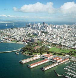 |
| Ft.
Mason: one small part of the Golden Gate National Recreation Area
(GGNRA), the largest federal urban park system in the world. Photo
courtesy Robert Campbell, Chamois Moon. |
Have we been missing the
boat?
"I believe that our
most underutilized resource in San Francisco is the Bay," comments
John Marks, President & CEO of the San Francisco Convention &
Visitors Bureau. "Not only would a circle route provide trips to
various points around the Bay, but there is no better way to enjoy the
beauty of the region. We think San Francisco looks good from land but from
the water, it’s magical," says Marks, a native San Franciscan and
now a Marin County resident.
"The key to making it
work is a high level of frequency, record of dependability, and quality of
service both for the resident and visitor markets."
Marks was inspired by what
he saw on Italy’s Lake Como where an extensive network of ferry
transportation carries tourists from Bellagio to Mennagio and other points
around the Alpine lake.
Richmond resident and
sailing enthusiast Lucie Van Breen delights at the recreational
possibilities. "I’d love to ride my bike from the Harbor Bay Island
ferry to the bird sanctuary on the tip of Alameda Island and then to the
Martin Luther King Shoreline Park and the Western Aerospace Museum. I
could also visit the Rosenblum Cellars at the Alameda Ferry Terminal. The
USS Hornet would be a gentle bike ride from there."
Ms. Van Breen misses
the discontinued Richmond ferry. "It’s the closest I’ve been to
my neighbors. You never think of talking to your fellow passengers on
a bus."
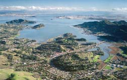 |
| Ferries
already serve Marin County from scenic points along the pictured
shoreline: Sausalito, Tiburon, and Larkspur. Photo courtesy
Robert Campbell, Chamois Moon. |
Ferries can bring visitors
and locals to many restaurant, shopping and entertainment attractions.
Oakland’s Jack London Square, for example, affords the ferry rider a
tempting array of eating establishments, blues and salsa clubs, bookstores
and retail outlets.
The creation of the
Eastshore State Park has fostered growing interest in easy public transit
access to these open spaces. Local citizens and park planners are now
looking at a variety of recreational alternatives including shoreline
trails, wildlife observation points, picnic and turfgrass areas, and
launch ramps for kayaks. The Eastshore State Park comprises about 1,800
acres of wetlands, beaches and uplands along eight miles between Oakland
and Richmond. The property has spectacular views of the Bay and San
Francisco.
Just to the north, the
Miller/Knox Regional Shoreline has become an attractive park for group
picnics, joggers and bicyclists, fishermen and kite fliers. The Golden
State Model Railroad Museum is right across from the park entrance.
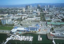 |
| Oakland’s
Jack London Square: Gateway toJazz, restaurants, and other
cultural attractions. Photo courtesy Bob Ecker |
Making the case for
increased investment
GGNRA is surveying
riders and potential riders to gauge the actual interest in new ferry
routes. They are looking not only at visitor flow but also at potential
terminal sites, environmental issues such as "wake erosion"
caused by ferries, and business issues facing ferry operators that would
make recreational routes economically feasible. The GGNRA expect to report
results from its study by June. It will then integrate its studies
with current WTA research on ridership estimates and costs.
GGNRA planning chief Mike
Savidge said, "We want our survey to complement the WTA’s
research." As they look at park and beach attendance numbers,
planners will inquire whether a policy of improved public park access
justifies investment in piers and ferries to serve these sites, and some
form of subsidy for the service.
The WTA’s study of
recreational ferry routes is part of a larger study that deals with water
transit as a means to alleviate traffic congestion in a cost-effective,
convenient and environmentally responsible system. WTA must submit its
findings and recommendations to the California Legislature in the form of
an Environmental Impact Report and an Implementation and Operations Plan
by June of 2003.
NEXT
PAGE
